Excellent, comprehensive site from National Geographic that provides lesson plans, activities, maps, …
Excellent, comprehensive site from National Geographic that provides lesson plans, activities, maps, and National Geography Standards. Teachers can find lesson plans based on grade and standard. Covers current issues, for example, global climate change, diminishing fresh water supplies, fossil fuels, etc.
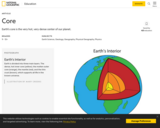
Understand the characteristics and features of Earth's core from this detailed article. …
Understand the characteristics and features of Earth's core from this detailed article. Includes high-quality illustrations, a downloadable poster, a video, and links to other resources.
A video discussing an invasive species of bullfrogs. Learn how conservations' fear …
A video discussing an invasive species of bullfrogs. Learn how conservations' fear that these frogs are overtaking an ecosystem. Includes teacher resources for learning. [6:10]
In this lesson, students learn to determine the latitude and longitude of …
In this lesson, students learn to determine the latitude and longitude of locations within the United States, while making observations about climate and the ways in which these measurements can be useful. Includes maps and discussion prompts.
National Geographic site engages users with colorful photos and extensive facts about …
National Geographic site engages users with colorful photos and extensive facts about Adelie Penguins. Be sure to click on the video link to view a short clip on these fascinating animals.
National Geographic site engages users with colorful photos and extensive facts about …
National Geographic site engages users with colorful photos and extensive facts about American Alligators. Be sure to click on the video link to view a short clip on these fascinating animals.
National Geographic site engages users with colorful photos and extensive facts about …
National Geographic site engages users with colorful photos and extensive facts about American Bullfrogs. Be sure to click on the video link to view a short clip on these fascinating animals.
National Geographic site engages users with colorful photos and extensive facts about …
National Geographic site engages users with colorful photos and extensive facts about Atlantic Puffins. Be sure to click on the video link to view a short clip on these fascinating animals.
Colorful photos and extensive facts about bald eagles. Includes links to a …
Colorful photos and extensive facts about bald eagles. Includes links to a short video clip of a bald eagle tending her young and to a map of the eagle's range.
National Geographic site engages users with colorful photos and extensive facts about …
National Geographic site engages users with colorful photos and extensive facts about Blue-Footed Boobies. Be sure to click on the video link to view a short clip on these fascinating animals.
National Geographic site engages users with colorful photos and extensive facts about …
National Geographic site engages users with colorful photos and extensive facts about Bull Sharks. Be sure to click on the video link to view a short clip on these fascinating animals.
National Geographic site engages users with colorful photos and extensive facts about …
National Geographic site engages users with colorful photos and extensive facts about Canada Geese. Be sure to click on the video link to view a short clip on these fascinating animals.
National Geographic site engages users with colorful photos and extensive facts about …
National Geographic site engages users with colorful photos and extensive facts about Cane Toads. Be sure to click on the video link to view a short clip on these fascinating animals.
National Geographic offers great information on this multi-media site all about chimpanzees. …
National Geographic offers great information on this multi-media site all about chimpanzees. See video, hear audio, learn fun facts and send a postcard to a friend.
National Geographic site engages users with colorful photos and extensive facts about …
National Geographic site engages users with colorful photos and extensive facts about Clown Anemonefish. Be sure to click on the video link to view a short clip on these fascinating animals.
Learn all about coyotes on this great multi-media site. Video and audio …
Learn all about coyotes on this great multi-media site. Video and audio clips, fun facts and great pictures make this a good National Geographic site for research projects.
No restrictions on your remixing, redistributing, or making derivative works. Give credit to the author, as required.
Your remixing, redistributing, or making derivatives works comes with some restrictions, including how it is shared.
Your redistributing comes with some restrictions. Do not remix or make derivative works.
Most restrictive license type. Prohibits most uses, sharing, and any changes.
Copyrighted materials, available under Fair Use and the TEACH Act for US-based educators, or other custom arrangements. Go to the resource provider to see their individual restrictions.